
Example of Coral reef found around St. John Islands. photo courtesy of seestjohn.com
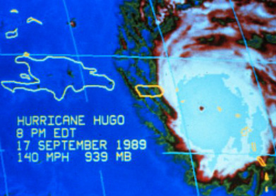
 St. John is surrounded by the Caribbean Ocean waters, south of the tropic of cancer, with the average temperatures of these coastal waters running between 77 and 84 degrees Fahrenheit. Although these surrounding seas keep the terrestrial climate cooler than other locations in the region, such as tropical mainlined Central America. Tradewinds blow from the east all year in this region and are at their strongest in the winter months. Due to the mean annual temperature at sea level, these islands are classified as subtropical. St. John has a very warm dry climate with most precipitation events lasting only a short time. Due to this fact, you may only get a few millimeters of rain with each shower. “There is a pronounced east-west rainfall gradient similar to many of the less mountainous islands of the Lesser Antilles, where the east end receives less than (75 cm) annually and the west end over (150 cm). Rainfall tends to be distributed irregularly throughout the year and between years. The variable rainy season is from September to December but rainfall can be concentrated during tropical storms and hurricanes (geographic consulting).” With each precipitation event generating only a few mm of rain, this leads to a higher level of evapotranspiration and is therefore often higher than that of the rainfall. In addition, there are lower levels of groundwater and groundwater recharge only happens after larger storms, such as tropical storms or hurricanes that can saturate the land. This Island is also positioned very near the Gulf Stream which and is subsequently threatened by more tropical storms or hurricanes. One of the most devastating Hurricanes to hit St. John was in 1989; Hurricane Hugo was a category 4 storm, with winds up to 225km. Storms of this nature are not only damaging to island structures, but also the coastal environments of islands, such as the coral reefs. Furthermore, prolonged periods of drought may typically from March to July. Coincidentally the hottest months are July through October, which corresponds with hurricane season. In recent years, it has been discovered that global warming may be having an effect on the St. John. Due to the increasing water temperatures around the island and the lower salinity in the water caused by rain in the area, Coral Reefs have become more prone to the damaging effects of water chemistry and temperature. When the water temperature increases in these areas it is known to cause the “bleaching” of reefs, this means that reef is expelling the algae from its tissue, leaving it a white color. Coral reef is also known to have a smaller tolerance for changes in the salinity of water. Most of these changes do come from the water temperature and the rains, as the island has no permanent streams to increase the sediment runoff affecting the oceans.
 These graphs demonstrate the weather patterns for the month of May 2014. courtesy of: http://www.wunderground.com/history/airport/TIST/2014/5/7/MonthlyHistory.html These graphs demonstrate the weather patterns for the month of May 2014. courtesy of: http://www.wunderground.com/history/airport/TIST/2014/5/7/MonthlyHistory.html 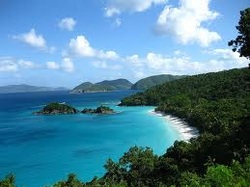 Weather remains somewhat stable in St. John. It is reflective of a tropical savanna climate and is affected by mostly moderate trade-winds. This area of the Caribbean is fortunate enough to have revolving warm water currents. As the island is located near the equator and the existence of the warm water current, this island has a high humidity factor as well as stable climate with an average temperature of 79.7. However, due to the relative humidity average of 74%, it has a tendency to feel much warmer. This area is flanked with mainly by cumulus clouds. These clouds help to provide coverage in the heat at times. However, they do not provide much rain to the area. On average, St. John receives only 40.29" of rain a year. While St. John does not have a specific rainy season, it does have certain months that tend to receive more rain. These months are: November, October, September, August and May. While these months may have more rain, it is not a common occurrence to have rain all day. In fact, most days of rain are scattered showers and produce about .10" of rain or less. The two months for driest weather are February and March, which average less that 2" of rain in each month. St. John Island has an approximate Bowen Ration of 1:10 as in most ocean areas. 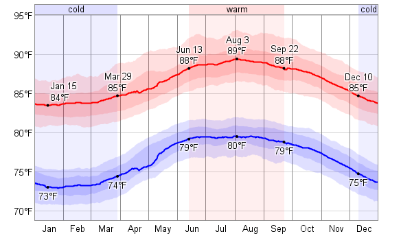 This is a graph showing the average annual temperature. Courtesy of:http://weatherspark.com 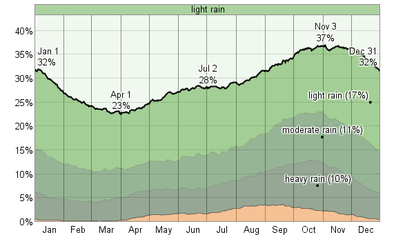 This is a graph showing the average annual precipitation. image courtesy of:http://weatherspark.com 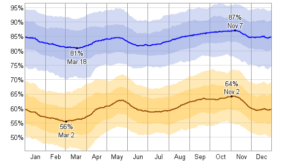 This graph demonstrates the regions high humidity. courtesy of:http://weatherspark.com 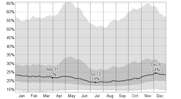 This graph shows the average area cloud coverage. As you can see it is quite low. courtesy of: http://weatherspark.com  Picture couresy of: www.cntraveler.com Picture couresy of: www.cntraveler.com St. John is located at approximately 18.3333° N, 64.7333° W. It is an island in the Eastern Caribbean Sea that has been part of the US territory since 1917. St. John sits nearly 1100 miles off of the coast of Florida and about 50 miles southeast of Puerto Rico. The climate is mild and summer like conditions can be found for much of the year. St. John's is approximately 20 square miles, about 7 miles long, 3 miles wide and with the highest point being a mere 1,277 ft. with roughly 2/3 of this island is national park land. Since 1956, 7200 acres has been deemed a national park, the Virgin Islands National Park, with miles of hiking trails and an additional 5600 acres of underwater national park lands that contain swim-able reefs, which are great for snorkeling. http://www.vinow.com/stjohn/History/
http://www.sailingdirections.com/caribbean-charter-guide#us-virgin-islands http://www.nps.gov/viis/planyourvisit/outdooractivities.htm http://www.seestjohn.com/about_st_john.html http://www.friendsvinp.org/ |

 RSS Feed